
Beit Leed (Arabic: بيت ليد) is a Palestinian town in the Tulkam Governorate in the northeastern West Bank located a few kilometers southwest of Tulkarm and west of Nablus . According to the Palestinian Central Bureau of Statistices, the town had a population of 4,994 inhabitants in 2007. In 1922, its residents amounted to 653, and then rose to 1,807 in 1961.
On the map 163.185 and rises from sea level 435m and descended the hill
of Beit Leed severe decline towards the south, where there is soil brown and
brown soil red on the south side of the hill while descended gradually
declining in the two northern and northwestern where spreading soil white and
extends the Mount in the North West and Mount Ras al-Shami in the north side of
town and the surface of the earth in the same Beit Leed covered with brown
soil.
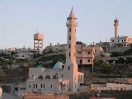
Town consists of houses
are built with stone and cement, especially older buildings that are not
separated in the center of town only alleys with a round shape or a
semi-circular therefore planned town circular radial cross the narrow streets
branching along the roads branching from Beit Leed, particularly in the Bank on both sides of the by Saffarin where almost all buildings of Beit Leed and
Saffarin coalesce with each other area of the town has increased as a result of this urban
growth of "22 acres" in 1945 to more than "150 acres" in
1980.
No comments:
Post a Comment